Hurricane Idalia's track is unprecedented — and dangerous

The powerful storm is destined for historically uncharted territory.
By Mark Kaufman  on 
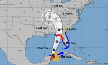
Hurricane Idalia approaching Florida on Aug. 29, 2023.
Hurricane Idalia approaching Florida on Aug. 29, 2023. Credit: NOAA

Hurricane Idalia is headed towards uncharted territory.

The storm, still intensifying, has reached Category 4 status (meaning winds over 130 mph) and is expected to make landfall Wednesday morning. It's on track to hit Florida's Big Bend region at a location no major hurricane — meaning Category 3 or higher — has ever historically landed.

"Hurricane #Idalia will likely be an unprecedented event for many locations in the Florida Big Bend," the Tallahassee National Weather Service office tweeted. "Looking back through recorded history, NO major hurricanes have ever moved through the Apalachee Bay. When you try to compare this storm to others, DON'T. No one has seen this."

"When you try to compare this storm to others, DON'T."

Forecasters emphasized that "there are NO major hurricanes in the historical dataset going back to 1851 that have tracked into Apalachee Bay. None. Don't mess around with this."

Crucially, this region is quite vulnerable to storm surge — the ocean water pushed onto shore, at times violently, by a tropical storm's strong winds.

Mashable Light Speed
Want more out-of-this world tech, space and science stories?
Sign up for Mashable's weekly Light Speed newsletter.
By signing up you agree to our Terms of Use and Privacy Policy.
Thanks for signing up!

"The Florida Forgotten Coast and Big Bend are some of the most surge-prone areas in the world. The terrain is essentially flat inland a long way from the coast," Clark Evans, a professor of atmospheric sciences at the University of Wisconsin–Milwaukee, noted online.

The surge will be serious. The National Hurricane Center projects 10 to 15 feet of surge in the area from Aucilla River to Yankeetown, Florida. It will be "catastrophic," the agency underscored.

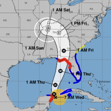
Hurricane Idalia's projected track as of 2 p.m. ET on Aug. 29, 2023.
Hurricane Idalia's projected track as of 2 p.m. ET on Aug. 29, 2023. Credit: NHC

Idalia strengthened into a hurricane on Tuesday, and is expected to continue intensifying. That's a major reason why the winds, and accompanying storm surge, are so extreme. Hurricane Idalia is benefiting from profoundly warm ocean temperatures, which fuel the storm, as well as a lack of opposing winds (wind shear) that can diminish a storm's power.

"We expect it to rapidly intensify," Joel Cline, the National Weather Service Tropical Program manager, told Mashable on Monday evening. "This will be a rapid intensifier from a tropical storm."

The storm's potent rain bands will drop deluges in the Florida region, and beyond, too. "Heavy rainfall and the potential for tornadoes are forecast as well," the National Weather Service said. Follow guidance from local officials and don't ignore the danger posed by freshwater flooding. In recent years, freshwater flooding from heavy deluges has driven the majority of tropical storm-caused deaths.

"The rain will come down heavily at times," Tony Fracasso, a National Weather Service meteorologist, told Mashable.

How is Hurricane Idalia related to climate change?

Climate change is impacting hurricanes. Some of these impacts are clear, particularly more serious rainfall and historic flooding, along with higher storm surges. Other impacts, like how the relentless warming oceans are affecting how strong these storms grow, are an intensive and ongoing area of research.

Mashable Image
Mark Kaufman

Mark is an award-winning journalist and the science editor at Mashable. After working as a ranger with the National Park Service, he started a reporting career after seeing the extraordinary value in educating people about the happenings on Earth, and beyond.

He's descended 2,500 feet into the ocean depths in search of the sixgill shark, ventured into the halls of top R&D laboratories, and interviewed some of the most fascinating scientists in the world.

You can reach Mark at [email protected].


Recommended For You
Hurricane Helene: Spaghetti models track the storm’s path
NOAA's cone model for Tropical Storm Helene

Hurricane Debby track shows Florida landfall near. See the path online
Forecast map for Hurricane Debby.

Hurricane Milton: Spaghetti models track the storm’s path
NOAA's cone model for Hurricane Milton


Hurricane Helene update: Track the Florida landfall path
NOAA's cone model for Tropical Storm Helene

More in Science
Deals under $25 still live after Prime Day: AirTags, speakers, more
An illustrated background with an Amazon Echo Pop, Amazon Fire TV Stick 4K, Apple AirTag, and Anker P20i earbuds.

The best Amazon Prime Day deals still live: Roomba, Apple, Dyson, and other top brands
various tech products

October Prime Day is over but no one told these wireless earbud deals
A person working out with a pair of Apple AirPods

Prime Day is over but you can still find deals on noise-cancelling headphones: Save on Apple, Beats, Sony
A pair of Amazon Echo Buds and Apple AirPods on an illustrated background.

Samsung Galaxy Prime Day deals are still live: Save $250 on cult-favorite Z Flip 6 AI phones
Samsung Galaxy devices overlayed on blue and green illustration

Trending on Mashable
Wordle today: Answer, hints for October 11
a phone displaying Wordle

NYT Connections today: Hints and answers for October 11
A phone displaying the New York Times game 'Connections.'

Astronomers just found a galaxy way too advanced for its time
Galaxy forming in the early universe

NYT Connections today: Hints and answers for October 10
A phone displaying the New York Times game 'Connections.'

Tesla’s surprise announcements: Robovan and Optimus
Two images side by side. On the left is a screenshot of the Robovan. On the right is a Tesla promotional image of an Optimus robot serving someone a drink.
The biggest stories of the day delivered to your inbox.
This newsletter may contain advertising, deals, or affiliate links. Subscribing to a newsletter indicates your consent to our Terms of Use and Privacy Policy. You may unsubscribe from the newsletters at any time.
Thanks for signing up. See you at your inbox!